New York (9 October – 11 October)
New York, New York (the state, not the city). We will avoid the city like the plague. Way too many people and traffic. Now if we had a small car and not the van that would be a totally different story. I would love to bird Central Park. We haven’t been there since 1989. And I wasn’t a birder then.
We left Gifford Woods State Park in the wee hours of the morning – okay it was around 8:00 a.m., but no one else in the campground (our loop anyway) was stirring. We stopped for breakfast at Sugar and Spice Restaurant on Highway 4, near the campground. The food was good and hearty. I had the pumpkin pancakes. Yum!!! The restaurant featured a lot of Vermont products (want a gallon of maple syrup?) and had a former maple distillery.

March of the Pink Flamingos

The truck had pink “Breast Cancer” ribbons
We then headed to New York, traveling down scenic Highway 22 south for most of the trip. This part of the state is very pretty, with pastoral scenes and quaint villages, although not a lot of “fall colors”. I guess they don’t have as many sugar maples or red maples as New England. We eventually made our way to the 700,000 acre Catskill Forest Preserve. We are staying for two nights at the North and South Lakes campground. Yes, this is the site I mentioned in the last blog that has supposedly 219 campsites, although we are in campsite #218 and I sure don’t see a #219. Maybe because they start with #0. We are in the ‘quiet’ loop, which is located away from the lakes. All the other loops are near North Lake.
After setting up camp we headed to the lakes (on foot) so we could hike the foot path around the two lakes. The day was perfect – sunny, mid 70’s, slight breeze. We couldn’t ask for a nicer afternoon. Oh it is so, so, so nice to see the sun again. I am a sun worshiper. I need the sun. When the sun shines, I feel like a million bucks. Can’t beat that feeling. So, the hike was about 2.5 miles in length, but we walked an extra mile as we walked to the trailhead from our campsite, about ½ mile each way. Tomorrow we anticipate doing some more hiking around the area.
The Catskill Forest Preserve could occupy a lot of time, but we will only see a small portion of the area, although we are not in any rush as we don’t need to be in Fort Lauderdale, Florida until November 8th – five weeks away. The following day we catch our plane to Cuba, where we will participate in a bird survey.

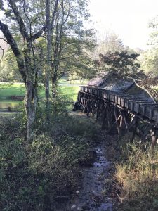
Hudson River – on the Rip Van Winkle bridge


Jack at the “north” lake at North and South Lakes Campground – Catskill Forest Preserve

The fall foliage is starting to appear


Looks like fun. Something I want to try.

Trail along the north side of “South Lake”

I thought this was neat. We should have something like this in Homer.

Large Hydrangea bushes everywhere

Finally a duck in plumage that is easily recognizable – okay for you non birders this is a Mallard (drake – male)

You can see that the roots like to hang on for dear life

Trail markers to show us the way

We loved how someone saw this large rock as a type of monster and added “teeth” and an “eye”.

Here is another one – people are so creative and imaginative

American Goldfinch

There’s got to be seeds in there somewhere
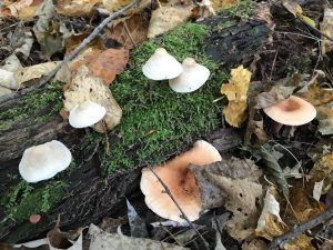
Mushroom and Fungi photos for the day – some really interesting stuff out in our forests.


A type of “bear’s tooth” fungi


Our first night here we had campers close by who decided they wanted to party starting at 9:00 p.m. and ending around a little after 2:00 a.m. They insisted on playing a boom, boom, boom, music and mixed that with alcohol. Needless to say, I didn’t get much sleep. So, after filing a complaint, we decided to find a new campsite in a different loop since the party group wasn’t leaving anytime soon.
After we set up in a new campsite (different loop), we were off on a 5.0-mile hike on a loop trail with views of Ashley Falls, Newman’s Ledge, Sunset Rock, and Artists Rock. The trail was very rocky, muddy, had a lot of exposed tree roots, but stunning views at exposed rock ledges and outcroppings. The going was slow. One could easily get injured on this trail and not be discovered for some time since it wasn’t very busy with hikers. Despite the treacherous trail conditions, the day for the hike was perfect – partly cloudy skies, light breeze, and temperatures in the low to mid 70’s. At Newman’s Ledge we had some beautiful views of the Hudson River valley.

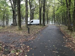
Our van in our campsite
We did encounter an interesting mix of people along the trail. One guy said he was training to hike up Mt. Washington with his grandkids (his wife sort of rolled her eyes). They wanted him to join them after he turns 70. Mt. Washington in New Hampshire is notorious for it fierce weather and wind, and difficult/strenuous trails. Funny, but you can never really tell how old people are because I would pegged this guy for being in his mid 70s at the youngest. I wonder how old he was. He looked a lot older than Jack, who has already passed his 70th birthday.

View of “North Lake”

Yellow-rumped Warbler


When leaves litter the trail it is sometimes difficult to see what is below – rocks, tree roots, wet soil … Well okay maybe you can see the rocks.

Ashley’s Waterfall

Another waterfall just up from Ashley’s Waterfall

The trail goes under the rock overhang

Trail marker

Trail

View looking down from the trail

Jack climbing up the trail

One of the few bridges along the trail – it was wet and slippery

Trail signage as there were several off-shoots from the trail we were on

Yes, that is our trail – up, up, up


Yes, this is the trail too


And this …

… and here too (trail)

View of the Hudson River Valley – not much color yet


Another slate of mushrooms and fungi observed while hiking.


Well all good things must come to an end, so the saying goes, including our beautiful sunshine and blue skies. We woke to rain. Luckily it held off to allow us to prepare breakfast and then hit with a force just after we left the campground. And boy did it rain – remnants of Hurricane Michael. In some places we had to put the windshield wipers at full strength just to be able to see out the windshield. There were flood warnings for parts of New York and Pennsylvania, but nothing in our path.
Before leaving we did have to check out Katterskill Falls in the Preserve. Katterskill Falls is the highest in New York state. They have a viewing platform where you can walk near the top of the falls. You can also take a path to the foot of the first drop (the falls has two drops). We chose not to take the path because of the rain. We weren’t sure how safe it would be since the trail is considered steep. We did take one of the scenic routes out of the Catskill Forest Preserve. Very pretty, although not much fall color – yet.

Trail to the Katterskill Waterfall

Upper fall of the Katterskill Waterfall

View from the waterfall viewing platform


Pennsylvania (11 October – 13 October)
After traveling on backroads through Pennsylvania, we finally got to our campground (Locust Lake State Park) around 5:00 p.m. and made ourselves a sandwich. Too wet outside to set up the stove and cook.
Locust Lake State Park is a large campground (277 sites), however several of the loops were closed. The campground officially closes October 23rd. Despite the weather – rain, and more rain in the forecast, much of the campground was booked for the weekend. We had thought about staying here two nights, but the campground seemed so dark and dreary we decided to find another campground for the next night.

Wet, wet, wet


In various towns in Pennsylvania they have these banners commemorating hometown military personnel that served in various wars
In the morning we were off to Hawk Mountain Sanctuary – Pennsylvania (http://www.hawkmountain.org). This sanctuary is a well known site for raptor migration. We hit it on a nice day (sunshine), although windy. Along with a hundred of our closest birding buddies, we watched as raptors soared into view and overhead. We saw a total of 11 raptor species: Sharp-shinned Hawk, Cooper’s Hawk, Northern Harrier, Bald Eagle (loved by most people there – but not us), Turkey Vulture, Black Vulture, Osprey, American Kestrel, Merlin, Peregrine Falcon, and Red-tailed Hawk.
We spent about two hours at the North Lookout hawk watch site with its commanding view of the valley. We even had two school groups of eager children joins us. The only birds to get real close were the vultures, and since these are big birds the kids really enjoyed watching them and got all excited. A Black Vulture even decided to sit on a stump within spitting distance of the kids.

Eastern Phoebe near the campground

Pennsylvania countryside – on the way to Hawk Mountain Sanctuary

So how big is that raptor? This sign shows the wingspan for each the raptors that might be seen there


This is a good primer for people – they need this as a handout


A very rocky trail. Good thing they mark the trees.

South Lookout. Not many people here. More action at the North Overlook.

North Lookout. As you can see there are a lot of people here. There were at least twice this many (and that was before the kids showed up).


A Black Vulture posing for the kids, well the adults too

Black Vulture

Mounts of the “Passenger Pigeon”, a bird that went extinct, due to overhunting, over a century ago.


Hawk Mountain Sanctuary got its start in 1934, when Rosalie Edge saw photos of hundreds of dead raptors killed by gunners. She leased the land (1,400 acres), installed a warden and a gatekeeper, and the killings stopped. Ms. Edge opened the sanctuary to the public and later purchased the property and deeded it to the Hawk Mountain Sanctuary Association. This association was incorporated in 1938 as a non-profit organization and has been in operation since. The sanctuary has since grown to 2,500 acres and now their mission is international. Way to go Ms. Edge! We need more people like her.
On the Hawk Mountain Sanctuary website you can get a count of the different raptor species seen during spring and fall migration (that day, total, and highest day count). Fall migration is when most of the birds are observed. In one day this year (September), 3,308 Broad-winged Hawks were observed. Now wouldn’t that be fun to see. We had a slow, but steady stream of raptors passing through. The staff observers are amazing with their ability to see and identify what often appears to be specks in the sky.
Oh, and at the gift store, I bought a book on mushrooms of Northeastern U.S. and Eastern Canada. Now I can go back and try and identify some of the mushrooms species I have been engrossed in photographing. But don’t expect identification of my mushroom/fungi photos. I still find identifying mushroom much, much more difficult than birds.
After we left the sanctuary we took the backroads to Gifford Pinchot State Park, our campground for the night. Several things I like about Pennsylvania State Parks – no alcohol and quiet hours are from 9:00 pm – 8:00 am. Okay maybe 8:00 am is a little late since that is when we generally leave most campgrounds. We had a sweet campsite. Lots of bird activity, although it was getting dark and thus hard to see the species when backlit and high in a tree. I was able to identify American Robin, White-breasted Nuthatch, Eastern Bluebird, and Yellow-rumped Warbler.
And guess what – we woke to rain at the park. I had thought about staying another night, but the forecast for Virginia – our next destination – was partly cloudy skies. Rain or partly cloudy skies, well that is a no-brainer, so off we went to Virginia.
Virginia (13 October – 15 October)
To get from Pennsylvania to Virginia we actually had to go through Maryland and West Virginia. Once in Virginia, we decided “why not take a really scenic route – the Shenandoah National Park Skyline Drive”. So we did. This is a 105-mile long drive along the ridge tops of the Blue Ridge Mountains. Along this 105-mile drive there are 40 lookouts/overlooks. We didn’t have the time to stop at all of them, but we did get in about 10 overlooks.
Since it was a Saturday, and it was nice out (although cold – 45 degrees F, with winds around 5 mph), there were a lot of people taking a weekend drive (we generally try to avoid major attractions on the weekend). All four campgrounds were full, and most of the trail parking lots were overflowing with cars. This drive is beautiful, especially with the sun filtering through the trees. Surprisingly, there was very little fall color despite the peak fall foliage season being between 10 October and 25 October.
We came to this park with our friend Dave in April 2014. At that time none of the trees were leafed out yet. Spring climbs up the mountains at 100 feet per day, beginning in March, with trees on the ridgeline (approximate 4,000 ft. elevation) not leafing out until late May. While the park in late April has a certain beauty of its own, it is much nicer when all the trees have leafed out. Today the drive was gorgeous with great views of the magnificent Shenandoah Valley.
We stayed the night at a wayside area along the Blue Ridge Parkway (managed by the National Park Service) because the campground we had hoped to stay at was full (it was a Saturday night). Hey, this way we don’t have to pay a fee. It was actually a nice pleasant night – little traffic on the road and the wayside had a picnic table so we were able to cook.
The Shenandoah Skyline Drive leads to the Blue Ridge Parkway, which extends 469 miles along the crests of the southern Appalachians linking the Shenandoah National Park on the north, to the Great Smoky Mountain National Park on the south – what great bookends! The Blue Ridge Parkway traverses two states – Virginia and North Carolina. Although the parkway begins at Rockfish Gap, we didn’t start there, but rather about 15 miles to the south (after finding a full campground).

Potomac River
These are photos from the various overlooks along the Skyline Drive at Shenandoah National Park.


Our second day in Virginia, and second day on the Parkway, we only journeyed around 150 miles south. The scenery was beautiful, when we could see it. At times we had rain and/or heavy fog. Kind of hard to check out the overlooks, when one can barely see the road. And it was weird being in the fog and then suddenly popping out of it from one valley ridge (gap or hollow) to the next. Kind of spooky in a sense. We hope to drive another couple hundred miles on the road.
There is no commercial traffic allowed on the road (kind of like the Natchez Trace Parkway) (Yay!!! No big trucks) and traffic is light. That might be due to the 35-45 miles per hour speed limit and lack of services (food, gas, lodging). Various exits go to towns and highway routes. And from the parkway you can occasionally see adjacent roads used by locals and the commercial trucks.
We are staying our second night along the parkway at the Rocky Knob campground (NPS). I was a little frantic thinking we might not get a spot since we didn’t get to the campground until around 5:00 pm. I needn’t worry as there are over 100 camping spots and probably less than 20 of them are filled. The campground was a little eerie due to the fog. With luck we will have a nice day tomorrow – at least no rain or fog. One can hope.


Otter lake, dam, and creek


James River wayside

James River

This pedestrian walkway under the bridge allows access across the James River to view historic locks

The locks

Yes, we did get a little fog. Hard to see much of anything. Not fun driving in these conditions even with a slower speed limit.


Roanoake River and Falls

Our van at Rocky Knob campground


Turkey Tails Fungi – and these really did look like turkey’s tails


Well it wasn’t raining when we woke up, but the wind was blowing pretty hard (approximately 10-15 mph). Luckily, it was a warm wind. We continued south on the Blue Ridge Parkway, making several stops along the way for features of attraction. The first stop was Mabry Mill. This is an old mill site operated by E. G. Mabry from 1910-1935. He had a sawmill, blacksmith shop, and a mill where he ground cornmeal and buckwheat (same mill as the sawmill) He also operated a whiskey still (hidden in the woods), and had equipment to make sorghum (think molasses – similar).

Mabry Mill


Whiskey Still

Inside the mill


Waterwheel – in operation


Press for the sorghum


The pond below the mill held a domestic Muscovy duck family. The male was snoozing, while the female was tending her brood of ten (so cute) busily feeding adjacent to the trail so a great view. At one point, mom decided to she wanted to take the young ones across the parkway road. Luckily the road wasn’t too busy. She waited until she couldn’t hear a car coming and then quickly crossed with her young ones. You might be wondering how I know she could “hear” the car coming. Well I watched for several minutes while she tried to cross the road. Whenever a car was near, she moved back to the grass. So maybe she “saw” the cars, rather than “heard” them, but she did know when to go and when not to go across the road.

Domestic Muscovy (female)

The babies were soooooooooo cute


Papa Muscovy

Keeping an eye on me
We journeyed on to make a quick stop to check out the Puckett Cabin. This cabin belonged to Orelena Puckett who became a midwife in her 50’s, and helped to deliver 1,000 babies; her last midwife delivery when she was 102 in 1939 (the year she died). She had 24 children of her own, yet none of them survived beyond infancy. Can’t imagine having 24 births. She got married at the tender age (maybe not then) of 16.

Puckett Cabin
Our next stop was at the Blue Ridge Music Center. This center is a celebration of Blue Ridge mountain music and musicians (think fiddles and dulcimers). Each day in the courtyard there are featured local musicians and today the four musicians were “The Buck Hollow Players” playing various instruments. One of them said they were not re-enacting what happened in years past because the music still continues today. On summer and fall weekends the Center features concerts, and fiddle contests are popular.


The Buck Hollow Players

Eastern Bluebird


North Carolina (15 October – 17 October)
Shortly after leaving the Blue Ridge Music Center we entered North Carolina, still on the Blue Ridge Parkway. Lands adjacent to the parkway are, for the most part, privately owned. At the beginning of the parkway (in Virginia), the Parkway passes through national forest land. There you rarely saw a structure. Once we began passing adjacent private lands we saw a lot more structures, although it was mostly farms with pastoral patches of green cut out of the treed landscape of the valley views. This landscape is especially true in North Carolina.


We made several stops along the route, including at Brinegar Cabin and the Northwest Trading Post. The Brinegar cabin was built around 1880. They had a photo of Martin and Caroline Brinegar and Caroline looks like a friend of ours – especially the eyes. The Northwest Trading Post offers crafts from North Carolina’s northwestern counties and China. Yes, there were many items with “Made in China” labels. There was a cute wooden plaque that read: Camping is spending a small fortune to live like the homeless. I almost bought that one.

Brinegar Cabin


I laugh every time I see this


We made it to our campground – Julian Price Memorial Park. The memorial park is the former retreat of Julian Price, an insurance executive. This is a good size campground operated by the National Park Service. We found a good site in loop A (site A-1), and quickly grabbed it. After setting up camp we took a 2.7-mile hike around the lake, adjacent to our campground loop. The trail was quite muddy, most likely from all the rain deposited by Hurricane Michael. Oh, but I found some mushrooms and fungi, so I was happy. Along the trail there were numerous Rhododendrons, which produce beautiful flowers in the spring. The Rhododendrons are also common along the parkway so I bet the Parkway and this trail are gorgeous when the flowers bloom in the spring.

Price Lake at Julian Price Memorial Park


Trail

… more trail

very muddy in parts (many parts)

Jack walking around some of the really muddy parts of the trail


Song Sparrow


This deer was just off the side of the road and nothing we did could get the deer to stop feeding


There are a lot of great “overlooks/lookouts” along the parkway, allowing the traveler to see distant forested valley vistas, 3-D like mountain scenes, and pastoral settings. The Parkway is truly a national treasure. I highly recommend the trip.
Our final day on the Blue Ridge Parkway was foggy, rainy, sunshine outbreaks, overcast skies. – we had a little of each. We made several stops, including two waterfalls: Linville Falls and Crabtree Falls. Linville Falls is named for a father and son who were killed by Indians while out “long hunting”. Long hunting is where you are gone for 6-12 months hunting for furs. We walked about ½ mile to the waterfalls – very nice – and then continued on to two additional overlooks of the falls. Also very nice. Of course we had to stop for birds along the way. At one spot, we had 11 different species, including two warblers: Bay-breasted Warbler and a Black-throated Blue Warbler. These birds weren’t in breeding plumage, but still great to see. And we had another Northern Cardinal – we’ve seen so few on our travels so far.


Linville Falls trail – the beginning anyway

Linville River

Linville Falls


the gorge

lower part of the Linville Falls – after the gorge
The trail to Crabtree Falls was all down hill – so of course up hill on the way back – with lot of rocks, exposed roots, and water where several small streams decided to jump their so called banks. The trail was 1.5 miles one way, but well worth the trip as the falls were spectacular.

Yes, this is the trail – a small part


These steps were very narrow …

… as were these

Crabtree Falls

Our final stop of the day was at the Folk Art Center near Ashville. They had some very nice, and very expensive items. I found a small quilt – about throw size – selling for $1,400. I’ve never seen a quilt that expensive. And we certainly didn’t see any “Made in China” items here. They also had some very nice displayed items: furniture, stained glass, etc.. Unfortunately, I wasn’t allowed to take photos.
Oh and today much of the parkway today traversed national forest land so the visits were rarely marred by man-made structures. Truly amazing views and we did start to get some color.
We decided to spend the night in Ashville. Probably a good thing too as it was raining quite heavily outside. Next we now make our way to Tennessee and the Great Smoky Mountains National Park. Tennessee is the only state in the nation I have not visited.

This is a pub on wheels and you peddle. These people were laughing and having fun despite the rain – downtown Asheville North Carolina
Okay and I cannot forget today’s mushrooms and fungi. I thought at first I wasn’t going to see much, but in one location along the Crabtree Falls trail I saw 11 different species in one small spot. Enjoy!!!


Until next time …
Leave a Reply